Updated 16 October 2026 · LocalKey consultant team
The Zhangye Colorful Danxia scenic area lies 40 km from Zhangye city in Gansu and has seven viewing platforms; its opening hours shift with sunrise and sunset, so check the official notice before planning a late-light shoot.
This page is for first-time visitors who want to photograph the striped hills of Zhangye. It is a planning page, not a photo tour. LocalKey does not sell group tours, and everything here is meant to help you decide how to spend one good day in the field. Facts come from the four sources listed at the end, and we mark our own advice as advice.
Where is Zhangye Danxia and what is protected there?
The Zhangye Colorful Danxia scenic area is in Linze and Sunan counties of Zhangye, Gansu, and covers 50 square km, according to the Zhangye Municipal Government. The same source says it is a national 5A scenic area, 40 km from Zhangye city and 20 km from Linze county town.
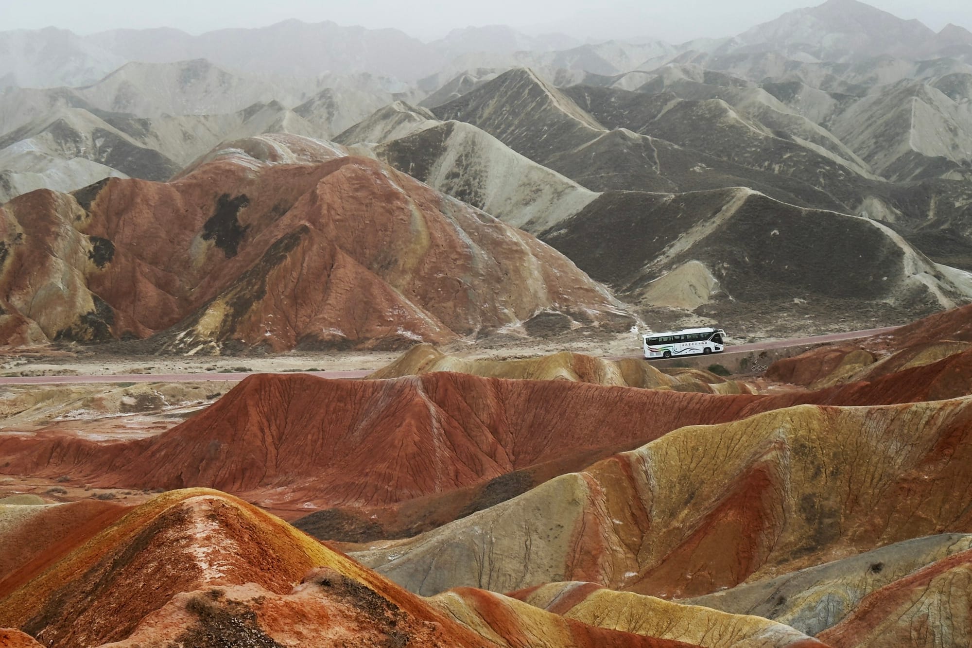
The rocks are Cretaceous "red beds", laid down between 135 and 65 million years ago. The Zhangye Municipal Government describes them as thick conglomerate and sandstone that were shaped by tectonic movement and by water and wind erosion. The colours it names are purple-red, grey-green, yellow-green and grey-black, found in thin interbedded layers of mudstone, sandy mudstone and shale. The core visitor area is 4 square km, which is much smaller than the full 50 square km, so you are not expected to cover the whole site in a day.
The same page calls the area a base for photography and film. The same municipal page lists Zhang Yimou's "The Great Wall" among the films shot there.
The wider protected context is the Zhangye UNESCO Global Geopark. UNESCO's geopark page says it was designated in 2020 and is centred on Sunan County, in the Qilian Mountains. UNESCO notes that it is known for its "Colourful Hills", where tectonic uplift formed monocline peaks, and for the Binggou Danxia, with its window-lattice and palace-style landforms. The geopark's official site gives its total area as 1,289.71 square km within Zhangye. UNESCO's geopark page also notes it was a field stop for the 30th International Geological Congress in 1996.
One point of wording matters. This is a UNESCO Global Geopark, not a World Heritage site, and the two are different designations.
The table below gathers the checkable facts for this page in one place, so you can compare them with the official notices before you book anything. It covers location, size, rock age, platforms, how hours are set, and the geopark context. All rows were checked on 16 October 2026.
| Fact | Detail | Source |
|---|---|---|
| Location | Linze and Sunan counties of Zhangye, Gansu; 40 km from Zhangye city, 20 km from Linze county town | Zhangye Municipal Government |
| Size | 50 square km in total; core visitor area 4 square km | Zhangye Municipal Government |
| Rocks | Cretaceous red beds, 135 to 65 million years old; conglomerate and sandstone shaped by tectonic movement, water and wind | Zhangye Municipal Government |
| Colours | Purple-red, grey-green, yellow-green, grey-black, in thin interbedded mudstone, sandy mudstone and shale | Zhangye Municipal Government |
| Viewing platforms | Seven: Qicai Yunhai, Qicai Xianyuan, Qicai Jinxiu, Qicai Hongxia, the Best Photography Point, Qicai Aohetai, Wanxiang Tulin Valley | Zhangye Municipal Government |
| Status | National 5A scenic area | Zhangye Municipal Government |
| Opening hours | Adjusted to follow sunrise and sunset; the 2024 example for 11 to 27 April was open 06:00, close 18:00 (an example only, not 2026 hours) | Zhangye Culture and Tourism notice |
| Hour changes | Announced on the scenic area's official WeChat account; enquiry phone +86 936 5623666 | Zhangye Culture and Tourism notice |
| Geopark | Designated 2020; centred on Sunan County in the Qilian Mountains; 30th International Geological Congress field stop in 1996 | UNESCO |
| Geopark area and help line | 1,289.71 square km within Zhangye; 24-hour service line +86 936 8800760 | Zhangye UNESCO Global Geopark official site |
Last verified 16 October 2026
Which Zhangye Danxia platforms can you photograph from, and how does each shoot?
The Zhangye Municipal Government lists seven viewing platforms, shown in the facts table above, inside a core visitor area of 4 square km. None of our four sources describes what each platform looks like, so the frame ideas below are our general suggestions, not tested findings and not a ranking.
The municipal page translates the platform names as Colorful Cloud Sea (Qicai Yunhai), Colorful Fairyland (Qicai Xianyuan), Colorful Brocade (Qicai Jinxiu), Colorful Rainbow Glow (Qicai Hongxia), the Best Photography Point, the Colorful Ao River platform (Qicai Aohetai) and Myriad Earth Forest Valley (Wanxiang Tulin Valley). We use the pinyin names from here on, because they match the municipal page; we have not checked how they appear on on-site signs.
We have not photographed these platforms for this page, so each idea below is a working hypothesis keyed to the platform's name and to general landscape technique. Test it on the day and trust what the light gives you over what we wrote here.
- Qicai Yunhai (Colorful Cloud Sea): the name points to a broad outlook, so a wide lens for the sweep of the layered ridges is a sensible first try.
- Qicai Xianyuan (Colorful Fairyland): a place to test a longer lens on single bands and the texture of the rock, if the view allows it.
- Qicai Jinxiu (Colorful Brocade): "brocade" suggests pattern, so try colour banding here, ideally when the light is soft rather than harsh.
- Qicai Hongxia (Colorful Rainbow Glow): a candidate for late light, as long as the day's closing time and last entry still let you reach it.
- Best Photography Point: this is the platform's own name in the source, not a judgement made by us or a promise of the best view.
- Qicai Aohetai (Colorful Ao River platform) and Wanxiang Tulin Valley (Myriad Earth Forest Valley): the valley name suggests a more enclosed frame than a ridge-top outlook. Check on the day which of these platforms are open.
We suggest choosing two or three platforms rather than trying all seven. The hills are striped in repeating bands of colour, so seven stops can give you seven similar pictures, while a slower visit to fewer places gives you time to wait for the light to change. Keep a loose list of preferred platforms and adjust it on the day according to where the light falls.
Some practical suggestions, all based on general photography habits rather than on source facts:
- Bring a wide lens for the sweep of the ridges and a longer lens to isolate single bands of colour.
- Carry spare batteries and a lens cloth, since the 2024 notice warns of frequent strong wind in spring and wind can carry dust.
- Dress warm and windproof if you visit in spring, as the same notice advises.
- If a platform is busy, keep your tripod bagged rather than blocking the walkway for other visitors.
- Check drone rules and any closed platforms on the official channel on the day, rather than assuming either.
Getting there and moving between platforms. The municipal page puts the scenic area 40 km from Zhangye city and 20 km from Linze county town. We have no sourced journey time and no sourced transport timetable, so ask your hotel or your LocalKey specialist to confirm the transfer. Do the same for how visitors move between platforms once inside, instead of assuming a particular route or a continuous walk.
Plan the day around the visitor areas and stay on the marked paths. We do not suggest planning any off-path ridge hiking, and the sources do not describe any.
When is the light best, and how do opening hours change?
Soft side-light in the early and late part of the day is the usual choice for photographing layered rock, but none of our four sources rates the best hour at this site, so treat that as general field practice. Because the scenic area adjusts its hours to follow sunrise and sunset, the official notice decides how much of that light you can actually use.
The scenic area's opening and closing times follow sunrise and sunset, according to a Zhangye Culture and Tourism notice dated 11 April 2024. That notice gave one example, 06:00 to 18:00 for 11 to 27 April 2024, and we show it only to illustrate how hours move, not as 2026 hours.
The same notice says ticket sales match the opening hours, and the last entry for the deeper visit is one hour before closing. In the 2024 example that meant 17:00. The practical point is that late light and last entry are linked: if you want to be on a platform at sunset, you need to be inside the deeper area before the last entry, not arriving at closing time.
Changes are announced on the scenic area's official WeChat account. The notice gives an enquiry phone number, +86 936 5623666. The geopark's official site lists a separate 24-hour service line, +86 936 8800760, which covers the geopark more widely. We have not tested either number for this page.
We have left out month-by-month sunset times on purpose. Sunset moves through the year, the scenic area's hours move with it, and an invented table would age quickly. Our suggested routine is simple:
- Choose your date, then check the official notice or WeChat account a few days before.
- Check again on the morning of your visit, since hours can be adjusted.
- Plan to reach your main platform well before the last entry for the deeper visit, so you are not rushed.
- Keep a second platform in mind in case wind, cloud or crowds spoil your first choice.
Reading the light on the ridges. These notes are general field habits, not verified claims about this site. Low, angled sun usually separates the colour bands of the rock best, and flat midday light usually does the opposite. Thin cloud can deepen colour, while thick haze tends to kill contrast. After rain, colours can read stronger, and wind-borne dust cuts clarity. The four colours in the facts table are the ones the municipal page names, so use them as a checklist of what to look for rather than as a promise of what the light will show.
A simple shape for the day (our suggestion). Spend the earlier part of your visit at a first platform in softer light, and leave a gap in the middle of the day for a second look at a different platform or for resting your eyes and your batteries. Then position yourself for late light, with the last entry time in mind. This pattern needs no source figures, only the day's official hours. It also leaves room for a change of plan if the wind rises or cloud rolls in.
If something goes wrong. These are our suggestions for common problems:
- Hours differ from what you expected: the official notice or WeChat account wins over this page and over the 2024 example.
- A platform is closed or crowded: move to your second choice rather than waiting indefinitely, and use the enquiry phone or your hotel to check what is open.
- Wind and dust: change lenses less often, shield the sensor, and use your lens cloth before shooting rather than after.
- Flat, hazy light: switch to tighter frames of single bands and texture, which hold up better than wide panoramas in poor contrast.
- You miss the last entry: the deeper visit is closed to you for that day, so build in a margin and keep a second day free if the weather is your main concern.
What do first-time visitors ask before shooting Zhangye Danxia?
First-time visitors usually ask whether they need a group tour (no; independent visits are possible, though we have not verified the ticketing steps for foreign visitors, see below), whether it is a World Heritage site (no; it is a UNESCO Global Geopark), and how to book and pay. The answers below give the detail; for light and timing, see the hours section above.
Do I need a group photography tour to shoot the Colorful Hills? No. The shoot is a ticket, the visitor path and your own timing for side-light and late colour. In our consultants' view, a fixed group schedule leaves less room to wait for the light, which is the main thing a photographer needs here.
How do foreigners book Zhangye Danxia tickets without speaking Chinese? Check the booking channel on the scenic area's official notice; the 2024 hours notice points to the scenic area's official WeChat account and the enquiry phone +86 936 5623666. We have not verified the ticketing steps for foreign visitors, so ask your hotel or your LocalKey specialist to check the current process with you. As a general habit in China, carry your passport on a sightseeing day. We do not list ticket prices, because they change.
Can foreigners photograph Zhangye Danxia without speaking Chinese? Nothing in our four sources restricts it, but we have not checked the English signage or the English-language help on site. Use a translation app, keep the enquiry phone number saved, and check the day's notice for closed platforms.
Is Zhangye Danxia a UNESCO World Heritage site? No. It is part of the Zhangye UNESCO Global Geopark, designated in 2020, and a national 5A scenic area. A Global Geopark and a World Heritage site are different designations.
Do I need a Chinese bank card to pay on a shoot day? We have not verified which payment methods the scenic area accepts, so we cannot say. Our suggestion is to set up Alipay for foreigners before your gate day, because a ticket queue is a poor place to bind a card, and to keep a second payment method as a backup.
What if the hours on this page differ from the hours on the day? Follow the official notice. The only hours on this page are the 2024 example, and they are there to show how the schedule moves, not to plan a 2026 visit.
How do you fit Zhangye Danxia into a Silk Road route?
Treat Zhangye as one stop in a longer Gansu route, not as a day trip from somewhere far away. The scenic area is 40 km from Zhangye city, and its core visitor area is 4 square km, which suits one focused photography day and a second day if you want a different platform at a different time.
The Zhangye UNESCO Global Geopark is centred on Sunan County in the Qilian Mountains, a county that UNESCO describes as the only Yugur autonomous county in China. Xi'an and Zhangye sit at different points on the Silk Road, so we suggest planning the route as a whole and leaving a margin for weather and changing opening hours, rather than fitting Zhangye into a tight gap.
If your route also includes Dunhuang, our Mogao Caves 2026 page covers that stop. For a wider view of planning camera-led trips across China, see China Photography Trip 2026. If you pass through Lanzhou on the way, our Lanzhou lamian page explains the city's listed noodle craft.
Zhangye Danxia is arid, colour-striped Danxia ridges shot from platforms, which makes it a different day from China's karst, lake, pillar and granite landscapes. If several of these are on one trip, we suggest treating each as its own shoot rather than stacking them into one long coach day.
- Dunhuang: the headline visit is the Mogao Caves, with timed cave entry and no mural photography inside, so it follows different rules from an outdoor platform day. See Dunhuang Mogao Caves 2026.
- Yangshuo: tower karst, cone hills and the Li River. See Yangshuo Photography 2026.
- Huanglong: travertine pools and terraces seen from a boardwalk. See Huanglong Photography 2026.
- Jiuzhaigou: an alpine-lake valley. See Jiuzhaigou Photography 2026.
- Zhangjiajie: a quartz-sandstone pillar forest. See Zhangjiajie Avatar mountains photography 2026.
- Huangshan: granite peaks, pines and sea of cloud on stone steps. See Huangshan Yellow Mountain hiking photography 2026.
- Longji: rice terrace ridges near Guilin. See Longji Rice Terraces Photography 2026.
If you searched for a group tour, our China group tours or a custom trip page explains the difference; LocalKey plans private trips only.
LocalKey can arrange this as part of your own China trip, planned, booked and backed by a specialist. There are two ways to do it, described in our private China tours:
- Independent: you travel on your own with the LocalKey app and 24/7 backup. A local guide, airport pickup, or a private car and driver can be added on demand.
- Private Guided: an English-speaking private guide and a private car stay with you throughout the trip.
Neither option is a group tour. Both are built around your dates, so you can place the Danxia visit at the time of year and the time of day that suits your camera plans.
Plan your trip with LocalKey
LocalKey can help you turn this page into a working itinerary, including the Zhangye day, the route to and from it, and a plan for checking the official opening notice before you go. We keep the trip flexible, so a change in wind or hours does not break the rest of your plan.
Talk to a 1:1 specialist, available 24/7 on WeChat or WhatsApp, and tell us your dates, your camera plans and which Silk Road stops you want to include. We will reply with a route that fits.
Sources
- Zhangye Municipal Government — Zhangye Colorful Danxia 5A scenic area — verified_on 2026-10-16
- Zhangye Culture and Tourism — Colorful Danxia opening and closing time notice (2024) — verified_on 2026-10-16
- UNESCO — Zhangye UNESCO Global Geopark — verified_on 2026-10-16
- Zhangye UNESCO Global Geopark — official site — verified_on 2026-10-16